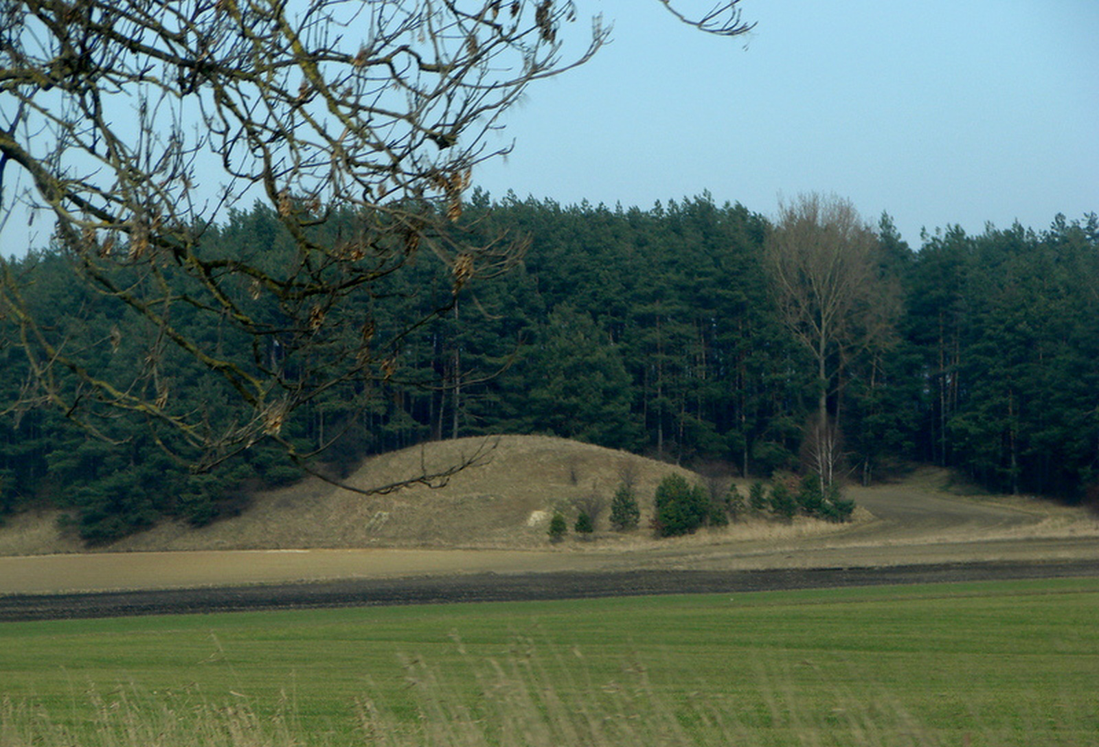
Motte-and-Bailey Stronghold Known as St. John’s Hill in Sampława
General Information
The stronghold most probably dates from the early Middle Ages and once served as a Prussian watchtower or a knightly seat.
Location / Geographical Setting
The stronghold is located in the centre of the village situated 4 km west of Lubawa and about 13 km south-east of Iława, by national road no. 15. The stronghold is situated approximately 150 m from national road no. 15, on its northern side, and about 100 m west of the bed of the Sandela River. From the south-west, the stronghold adjoins the edge of the moraine upland, while on the remaining sides its area is bounded by deep ravines used for agriculture.
History
Sampława was founded in 1339 under Chełmno law, when the Teutonic Grand Master Dietrich von Altenburg (d. 1341) granted Tyderyk (or Fryderyk) of Skarlin 10 łans of land under Chełmno law, imposing on the owner the obligation of mounted military service.
The object discussed here is a small motte-and-bailey stronghold, probably dating from the late Middle Ages. It once served as a Prussian watchtower or a knightly seat – it may have been a small single-manor stronghold. Situated on a hill, the stronghold was surrounded by a moat and an earthen rampart. It is assumed that it functioned between the thirteenth and fifteenth centuries. It cannot be ruled out that this was the seat of Szymon of Sampława, who in 1454 played an important role in actions directed against the Teutonic Order.
Over time, the place acquired religious significance, because in the nineteenth century the chapel of St. John the Baptist was located here, from which the present name of the hill derives. St. John’s Hill is now a picturesque viewpoint concealing traces of past human presence in the Lubawa region.
Present Condition
The stronghold has the form of a relatively regular mound with a flattened top, its base measuring approximately 70 x 55 m. At its summit there is a small oval depression, situated asymmetrically in relation to the axis of the object. At the point where the stronghold connects with the moraine upland, a shallow hollow has been preserved, interpreted as the remains of a moat. The elevation rises about 12 m above the surrounding depressions of the terrain, while the diameter of its summit part ranges from 10 to 14 m.
In 1968, brief reconnaissance and test excavations were carried out on the site of the stronghold under the direction of Andrzej Kola. During this work, cultural layers up to approximately 90 cm thick were identified, containing brick rubble interpreted as the remains of a nineteenth-century chapel, pottery fragments, and numerous traces of burning. Additional surface surveys in the surroundings of the stronghold made it possible to establish that on the south-eastern side, in the area of the moraine upland, there existed a settlement chronologically connected with the use of the stronghold.
Bibliography
- "Former Slavic Settlements in Pomerania" ("Dawne osiedla słowiańskie na Pomorzu"), „Młody Gryf”, 1933, vol. III, no. 39, pp. 4-5.
- Jan Falkowski, "The Lubawa Region – Nature, History, Settlement, Society, Economy" ("Ziemia lubawska – przyroda, historia, osadnictwo, społeczeństwo, gospodarka"), Toruń 2006, pp. 104-105.
- Kazimierz Grążawski, "The Lubawa Region on the Slavic-Prussian Borderland in the 8th–13th Centuries. A Study on the Development of Settlement" ("Ziemia lubawska na pograniczu słowiańsko-pruskim w VIII-XIII w. Studium nad rozwojem osadnictwa"), Olsztyn 2009, p. 203.
- Kazimierz Grążawski, "The Lubawa Region in the Early Middle Ages (from the 8th Century to the First Half of the 13th Century)" ("Ziemia lubawska we wczesnym średniowieczu (od VIII do pierwszej połowy XIII wieku)"), in: "Lubawa. History of the Town and Region" ("Lubawa. Dzieje miasta i regionu"), ed. Kazimierz Grążawski, Lubawa 2016, p. 73.
- Prussian Strongholds and Routes ("Grodziska i szlaki Prusów"), https://grodziska.eu/ziemia-sasinow/, [accessed: 12.09.2025].
- Gustav Liek, "The Town of Lubawa in West Prussia, with Consideration of the Lubawa Region" ("Miasto Lubawa w Prusach Zachodnich z uwzględnieniem Ziemi Lubawskiej"), ed. Andrzej Radzimiński, trans. Liliana Lewandowska, Lubawa 2016, p. 410.
- Andrzej Kola, "Strongholds of the Chełmno Land in the Late Middle Ages" ("Grody ziemi chełmińskiej w późnym średniowieczu"), Toruń 1991, p. 208.
- Stanisław Kujot, "History of Royal Prussia", part 1: "Until the Year 1309" ("Dzieje Prus Królewskich, cz. 1: Do roku 1309"), „Roczniki Towarzystwa Naukowego w Toruniu”, 1913, vol. 20, pp. 176-177.
- "Historical-Geographical Dictionary of the Chełmno Land in the Middle Ages" ("Słownik historyczno-geograficzny ziemi chełmińskiej w średniowieczu"), prepared by Krystyna Porębska, with the cooperation of Maksymilian Grzegorz, ed. Marian Biskup, Wrocław et al. 1971, p. 113.
- Robert Sypek, "Castles and Defensive Structures of the Teutonic State", part 2: "Pomesania, the Sasin Land, and the Lubawa Land" ("Zamki i obiekty warowne Państwa Krzyżackiego, cz. 2: Pomezania, Ziemia Sasińska i Ziemia Lubawska"), Warszawa 2000, p. 123.
- Józef Śliwiński, "Lubawa. From the History of the Town and Its Surroundings" ("Lubawa. Z dziejów miasta i okolic"), Olsztyn 1982, p. 25.
- "The Lubawa Region. A Guide to Monuments" ("Ziemia Lubawska. Przewodnik po zabytkach"), [Rybno c. 2015], pp. 44-45.