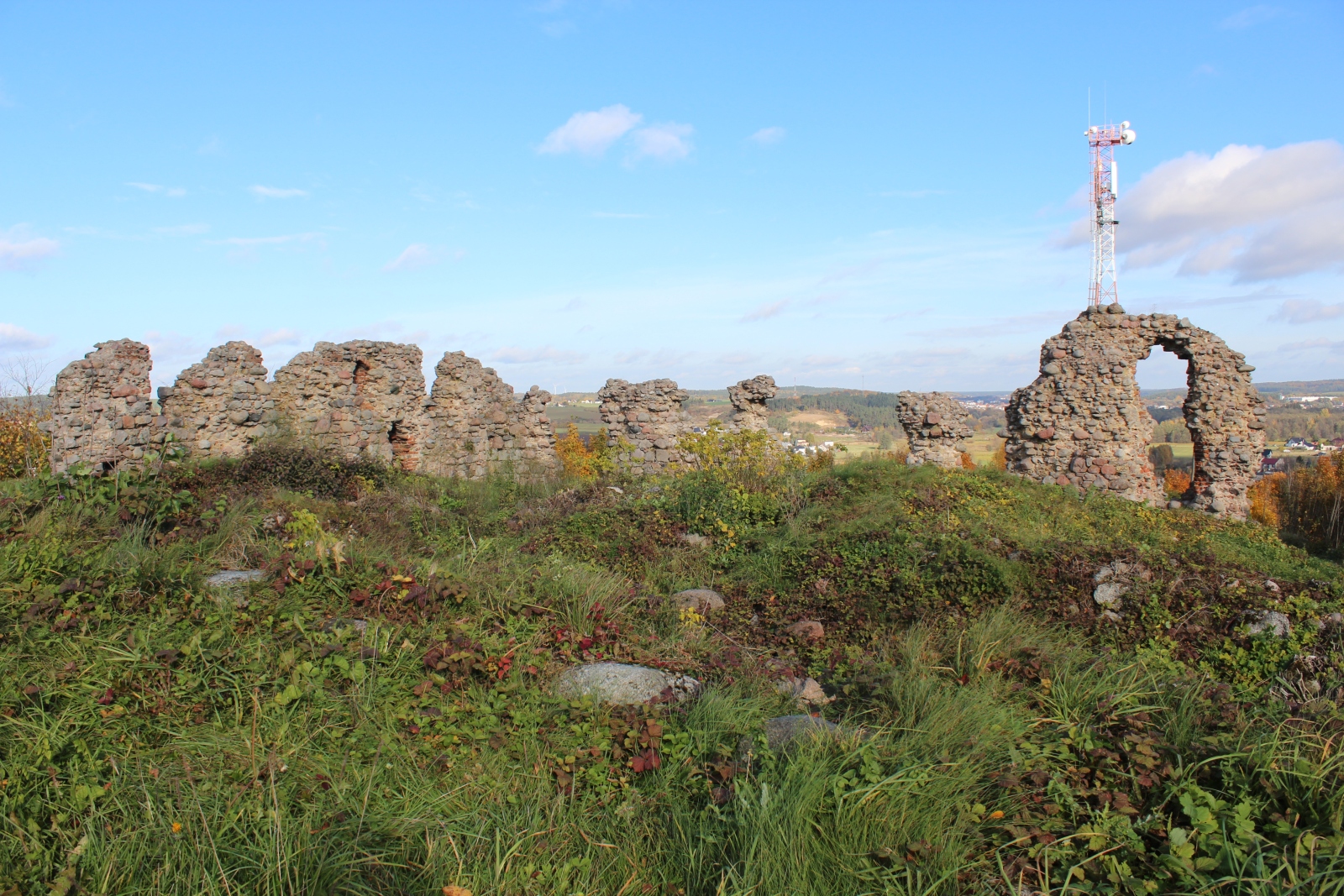
Ruins of the Castle of the Chełmno Chapter in Kurzętnik
General Information
The ruins of the castle of the Chełmno Chapter in Kurzętnik, picturesquely situated on a hill above the Drwęca valley, are the remains of a fourteenth-century Gothic stronghold. At present, the site, accessible free of charge to visitors, functions as a preserved ruin. It is reached by a path with the Stations of the Cross beginning at the local church.
Kurzętnik (formerly Kauernik) is the seat of a rural commune located in the Warmian-Masurian Voivodeship, in Nowe Miasto County. Although it held town rights historically from the fourteenth century until 1905 and has a character based on developed services, it formally functions as a village. Kurzętnik is the main administrative centre for 18 localities in the commune. In 2021, it had 3,280 inhabitants.
Location
The ruins of the castle of the Chełmno Chapter are located at the southern end of the village. The castle complex was erected on the summit of a high, elongated hill situated on the southern bank of the Drwęca River valley.
History
Over the centuries, the name of the castle and the locality appeared in various forms: Chornichium, Kurnig, Kiwernick, Kurnyk, Kawerneck, Cawenigk, Cauernik, Cuvwernick, Kuyrnigk, Kurzantnik.
The construction of the brick castle probably began in the mid-fourteenth century, after the Lithuanian raid of 1331. The stronghold was erected in stages during the fourteenth and fifteenth centuries. The first stage of construction was completed before 1361. The site belonged to the Chełmno Chapter and fulfilled an economic and defensive function. From the fourteenth century until the first half of the fifteenth century, the administrator of the Chapter’s Lubawa estates resided there. After the Battle of Grunwald (15 July 1410), the castle was taken over by Polish troops and remained in their hands until the following year. After the First Peace of Thorn (1411), Kurzętnik returned under Teutonic rule. The first serious damage to the stronghold occurred in 1414 as a result of a raid by Polish forces during the so-called “Hunger War.” The destruction, however, was quickly repaired, and already in 1414 a burgrave resided there. In 1454, Kurzętnik joined the Prussian Confederation, as a result of which the castle was captured and burned by the Teutonic Knights. After the Second Peace of Thorn, Kurzętnik was incorporated into Poland. The castle lost its military significance and was used for economic purposes. By the end of the sixteenth century, it was already described as “a building in ruin.” Further devastation took place during the Swedish Deluge in 1656. It is certain that at least until the early 1660s a chapel functioned within the castle. Source records from 1666 described the structure as “an old uninhabited ruined castle.” In the second half of the eighteenth century, the castle walls were dismantled, and the recovered material was used for new constructions. In the 1960s, archaeological works were carried out on Castle Hill.
Architecture of the Castle
The defensive complex in Kurzętnik had a three-part structure and comprised the upper castle, an elongated outer bailey, and a tower with residential and defensive functions. The highest part was the upper castle, a single-wing structure built on a plan close to a square measuring approximately 25 x 27 m. It was located at the culminating point of the hill. The construction was erected mainly of glacial erratic stone dressed on the face side, whereas brick was used only sporadically in the upper parts of the walls and around selected window openings. On the south side there was a multi-storey residential building reinforced with massive buttresses at the corners, while on the north side a small projection was added. On the same side, there adjoined a spacious quadrangular courtyard surrounded by a defensive wall. In the northern section of the wall there was a gate leading toward the bailey. The central part of the entire complex was the outer bailey, referred to as the lower castle. It had the form of an elongated trapezium approximately 60 m long and was enclosed by a wall running along the edge of the hill. In the western section of the perimeter, a rectangular tower was erected, while on the eastern side there was a square tower, slightly shifted to the north. Both towers projected in front of the face of the walls. Within the bailey there were probably residential buildings for servants and economic structures such as stables, granaries, workshops, and other utility buildings arranged along the walls. To the north was located the third part of the complex, called the chapel. It was a massive, multi-storey residential tower on a rectangular plan measuring approximately 8 x 13 m. Although the function of the individual rooms is no longer known, at ground-floor level there was a chapel dedicated to the Holy Cross. The structure had a distinctly defensive character and was reinforced with powerful buttresses on the north, east, and west sides. The southern spur of the hill on which the castle stood was separated from the rest of the terrain by a broad ditch approximately 25 m wide. The probable access route led from that side—across a bridge over the moat, then through a gate in the outer wall, further along the walls of the tower, through the zwinger on the eastern side and another gate, and finally onto the main courtyard. Due to its rather limited defensive system, the castle in Kurzętnik did not serve as an important fortress of strategic significance for the state. Its role was limited mainly to local functions.
Present Condition
To the present day, only the remains of the castle buildings have survived: fragments of the external walls of the main residential house rising to a height of approximately 6-8 m, as well as relics of the foundations of the perimeter walls and of the tower with residential and defensive functions.
Bibliography
- "Architektura gotycka w Polsce", ed. Teresa Mroczko, Marian Arszyński, vol. 2: "Katalog zabytków", ed. Andrzej Włodarek, Warszawa 1995, pp. 133, 318.
- Baliński Michał, Lipiński Tymoteusz, "Starożytna Polska pod względem historycznym, jeograficznym i statystycznym opisana", vol. 1, Warszawa 1843, pp. 640-641.
- Bałdowski Jan, "Warmia i Mazury. Mały przewodnik", Warszawa 1977, p. 127.
- Bałdowski Jan, "Warmia, Mazury, Suwalszczyzna: przewodnik", Warszawa 1996, p. 113.
- Bieszk Janusz, "Zamki państwa krzyżackiego w Polsce", Warszawa 2010, pp. 63-64.
- Czubiel Lucjan, "Zamki Warmii i Mazur", Olsztyn 1986, pp. 30-32.
- Falkowski Jan, "Ziemia lubawska – przyroda, historia, osadnictwo, społeczeństwo, gospodarka", Toruń 2006, pp. 109-112.
- Grabowski Jan, "Przewodnik. Nowe Miasto Lubawskie, Kurzętnik, Bratian", Nowe Miasto Lubawskie 1992, pp. 17-18.
- Grążawski Kazimierz, "Ziemia lubawska na pograniczu słowiańsko-pruskim w VIII-XIII w. Studium nad rozwojem osadnictwa", Olsztyn 2009, p. 194.
- Haftka Mieczysław, "Zamki krzyżackie w Polsce. Szkice z dziejów", Malbork-Płock 1999, pp. 140-142.
- Kajzer Leszek, Kołodziejski Stanisław, Salm Jan, "Leksykon zamków w Polsce", ed. Leszek Kajzer, Warszawa 2001, p. 257.
- Korycka Wanda, "Z przeszłości miast i osiedli", in: "Nowe Miasto: Z dziejów miasta i powiatu", Olsztyn 1963, pp. 201-203.
- Kurzętnik, in: "Słownik geograficzny Królestwa Polskiego i innych krajów słowiańskich", vol. IV, ed. Filip Sulimierski, Bronisław Chlebowski, Władysław Walewski, Warszawa 1883, p. 946.
- Liek Gustav, "Miasto Lubawa w Prusach Zachodnich z uwzględnieniem Ziemi Lubawskiej", ed. Andrzej Radzimiński, trans. Liliana Lewandowska, Lubawa 2016, pp. 122-126.
- "Słownik historyczno-geograficzny ziemi chełmińskiej w średniowieczu", prepared by Krystyna Porębska, with the cooperation of Maksymilian Grzegorz, ed. Marian Biskup, Wrocław et al. 1971, pp. 62-63.
- Sypek Agnieszka, Sypek Robert, "Zamki i obiekty warowne od Malborka do Torunia", Warszawa 2004, pp. 73-75.
- Sypek Robert, "Zamki i obiekty warowne Państwa Krzyżackiego", part 2: "Pomezania, Ziemia Sasińska i Ziemia Lubawska", Warszawa 2000, pp. 131-135.
- "Śladami Mikołaja Kopernika/In the Footsteps of Nicolaus Copernicus/Auf den Spuren von Nicolaus Kopernicus", introduction by Jerzy Sikorski, Lidzbark Warmiński 2022, pp. 20-21.
- Tarasewicz Hanna, Tarasewicz Stanisław, "Zamki, pałace i inne zabytki na Mazurach i Warmii. Przewodnik po skarbach Mazur, Warmii i Malborka", Kętrzyn 2000, p. 94.
- Torbus Tomasz, "Zamki konwentualne Państwa Krzyżackiego w Prusach", [part 1], Gdańsk 2014, p. 145.
- Wagner Adam, "Murowane budowle obronne w Polsce X-XVII w.", vol. 1, Warszawa 2019, pp. 807-809.
- Wasik Bogusz, "Budownictwo zamkowe na ziemi chełmińskiej (od XIII do XV wieku)", Toruń 2016, pp. 312-313.
- Woźniak Ryszard, "Fortyfikacje w dawnych Prusach Królewskich w pierwszej połowie XVII wieku", Warszawa 1974, pp. 56-58.
- "Ziemia Lubawska. Przewodnik po zabytkach", [Rybno 2015], pp. 28-33.