Copernicus Trail
Home/Nicolaus Copernicus

Nicolaus Copernicus

Interactive 3D exhibition: model, roles, biography, AR gallery, educational resources and a virtual walk through the Copernicus land units.

Education Area

Learn about Copernicus — flashcards, quiz and lessons

Resources for students and teachers: interactive flashcards for revision, a knowledge quiz with hints and explanations, and ready-to-use lesson scenarios from the Copernican cycle.

1 / 67
Question 1 / 10 · Result: 0
How did historians establish the exact date and time of Nicolaus Copernicus’s birth?
💡 Hint

Consider astrological documents, which were popular at the time and often contained precise biographical data.

1 / 10
đŸ›ïžLesson 1
Culture and memory

Nicolaus Copernicus today – how do we remember the great scholar?

„How do we remember the great scholar?”

⬇ .docx
🎹Lesson 2
Renaissance man

Nicolaus Copernicus – a Renaissance man

„Why do we call him a Renaissance man?”

⬇ .docx
⚕Lesson 3
Medicine

Nicolaus Copernicus as a physician

„What did it mean to be a physician in Copernicus’s time?”

⬇ .docx
§Lesson 4
Law

Nicolaus Copernicus as a lawyer

„Why was legal education important in Copernicus’s life?”

⬇ .docx
⛃Lesson 5
Economics

Nicolaus Copernicus as an economist

„What did Copernicus understand about money?”

⬇ .docx
☉Lesson 6
Astronomy

Nicolaus Copernicus as an astronomer

„Why did his discovery change thinking about the world?”

⬇ .docx
đŸ‘ȘLesson 7
Family and private life

What do we know about the private life of Nicolaus Copernicus?

„What role did his family environment play?”

⬇ .docx

3D Models · AR

Instruments and 3D reconstructions

Animated 3D models of astronomical instruments and digital reconstructions of Copernican objects. Rotate them, inspect details and launch AR view on a phone.

🔭

Copernicus’s astronomical instruments

The models show selected astronomical instruments used or discussed in the context of observations carried out in the age of Copernicus.

▶ Animation · AR

📐 Parallactic triangle (triquetrum)

A wooden parallactic instrument used by Copernicus. It served to measure the zenith distance of celestial bodies, that is, the angle between the direction to a star and the vertical. The animation shows the movement of the instrument’s arms during measurement.

▶ Animation · AR

🧭 Astrolabe

A multifunctional astronomical instrument used to determine the position of the Sun and stars, measure time and determine the altitude of celestial bodies above the horizon. Rotate the model and observe the motion of its movable rings.

▶ Animation · AR

📐 Solar quadrant

An instrument in the shape of a quarter circle used to measure the altitude of the Sun and stars above the horizon. The animation illustrates the movement of the shadow and the reading of the angle on the scale.

▶ Animation · AR

đŸ•°ïž Sundial

A timekeeping device that determines time from the position of the shadow cast by a pointer, or gnomon. The animation shows the movement of the shadow during the day and the markings of the seasons.

đŸ§©

3D reconstructions

The models present Copernican objects in the context of their history. They combine surviving monuments, lost architectural elements and details digitally reconstructed from old photographs and conservation descriptions.

▶ Animation · AR

🗿 Nicolaus Copernicus monument in Olsztyn

LocationPodzamcze Park on the Ɓyna River, near the Castle of the Warmian ChapterAuthorJohannes Götz (1865–1934)Unveiling9 November 1916Materialbronze bust on a granite pedestalProtectionentered in the register of monuments in 1997

The bust of Nicolaus Copernicus in Podzamcze Park is the oldest surviving Olsztyn monument dedicated to the astronomer. The model refers to the original, more elaborate composition with a canopy supported by pillars.

Significance

The monument is one of the most important elements of Olsztyn’s Copernican landscape of memory. It combines artistic, historical and landscape values, and its proximity to the castle recalls Copernicus’s stay as administrator of the estates of the Warmian chapter.

History

  • The initiative to erect the monument came from the Olsztyn Town Council in 1913, on the 440th anniversary of the astronomer’s birth.
  • Originally, the bust stood in front of the castle causeway, on a pedestal sheltered by an architectural canopy. This setting gave it the character of a representative gateway of memory on the approach to the castle.
  • Before the Red Army entered Olsztyn in January 1945, the bust was dismantled and moved to the castle. In 1946 it was placed on the western side of the castle, in Podzamcze Park.
  • After the war, the pedestal and inscription were changed, incorporating the former monument into a new narrative of Copernicus as defender of Olsztyn and a figure connected with the Polish tradition of Warmia.
  • In 2021, after an act of vandalism, the bust underwent conservation and was placed back on its pedestal.

Description of form

The sculpture depicts the scholar in mature age, with characteristic long hair. His face conveys concentration and seriousness, while his gaze is directed slightly upward, symbolically referring to Copernicus’s astronomical passion.

3D reconstruction

The model makes it possible to see the monument not only as the contemporary bust in Podzamcze Park, but also as an object with a lost pre-war architectural setting. This helps explain how the functions of memory and the meanings attributed to the same monument changed over time.

Sources
  • Götz Johannes Gottfried, Bust of Nicolaus Copernicus, bronze, granite pedestal, 1914/1916, Podzamcze Park in Olsztyn, entered in the register of monuments in 1997.
  • Joanna Kiewisz-Wojciechowska, The oldest Nicolaus Copernicus monument in Olsztyn has returned to Podzamcze Park, dzieje.pl, accessed: 12.10.2025.
  • Izabela Lewandowska, Warmia and Masuria as a palimpsest, or on adapting formerly German space after the Second World War, 2018.
  • Barbara Ohm, Johannes Götz 1865–1934. Bildhauer in FĂŒrth und Berlin, FĂŒrth 2008.
  • Olsztyn. Sculptures and monuments. Old Town and surroundings, Olsztyn 2021/2022.
▶ Animation · AR

đŸ–Œïž Relief from the Nicolaus Copernicus Bridge in Lidzbark WarmiƄski

Locationbridge over the Ɓyna River, between MƂawska Street and Koƛcielny SquareYear of bridge construction1909Technologyone of the first iron and concrete structures in Lidzbark WarmiƄskiFate of the chapel-like elementdismantled in 1939; the plaque disappeared after 1945Bridge renovation2016

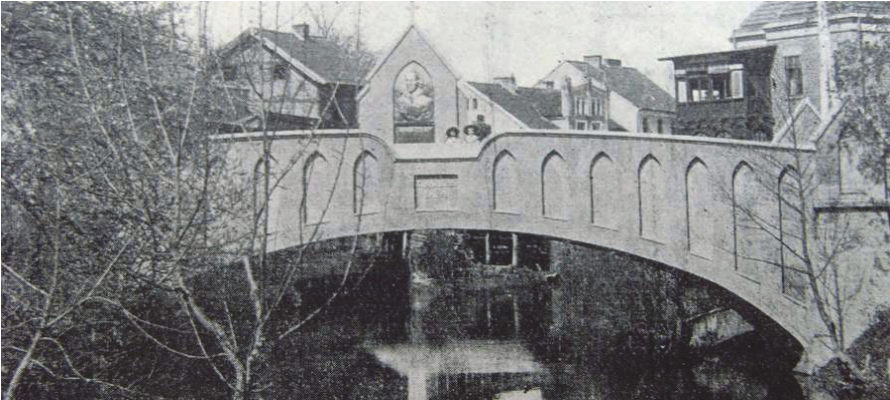
A digital reconstruction of a no longer existing chapel-like element with a relief or bust of Nicolaus Copernicus, formerly located in the western balustrade of the reinforced concrete bridge over the Ɓyna River.

View of the Nicolaus Copernicus Bridge in Lidzbark WarmiƄski around 1920, with the chapel-like element and Copernicus relief in the balustrade.
View of the bridge around 1920. Source photograph used as the basis for the digital reconstruction of the relief.

Significance

The Nicolaus Copernicus Bridge is an important element of the material heritage of Lidzbark WarmiƄski. It connects the history of early twentieth-century modern construction technologies with local memory of Copernicus and the former iconography of the town.

History

  • The bridge was built in 1909, most probably by the company Drenckhahn & Sudhop from Braunschweig, using reinforced concrete technology.
  • It replaced an earlier pipe bridge, whose pipes supplied water to the town from a spring on the southern side of the river.
  • A chapel-like element with a relief depicting a bust of Nicolaus Copernicus was placed in the western balustrade.
  • In 1939, the chapel-like element was dismantled because its weight overloaded the bridge and may have contributed to cracking of the structure.
  • The plaque was moved to the area near the outer ward of the Lidzbark castle, but disappeared after 1945.

Description of the bridge

The concrete, single-span bridge has an arched vaulted structure. The span is 17 m, the total length is 30.75 m, the total width is 2.9 m, and the usable width is 2.2 m. The chapel-like pylons at the ends of the bridge are about 2 m high and are covered with gable-shaped concrete roofs.

The lost chapel-like element

The no longer existing chapel-like element with the image of Copernicus was about 4 m high from the pavement level, about 1.8 m wide and 30–40 cm thick. The bronze plaque measured about 1.8 × 0.9 × 0.1 m and weighed approximately 1.5 tonnes.

3D reconstruction

The model restores the visibility of a lost detail that for decades was known only from old photographs and conservation descriptions. The virtual reconstruction shows how the chapel-like element structured the view of the bridge and how strongly it connected an engineering structure with the memory of Copernicus.

Sources
  • Marian Biskup, Spatial development of Lidzbark WarmiƄski, Komunikaty Mazursko-WarmiƄskie, 1961.
  • WiesƂawa Chodkowska, Historical and conservation study of the bridge/footbridge in Lidzbark WarmiƄski, 2015.
  • Katarzyna Mossor, Bartosz Tomczak, Analysis of the causes of damage to the historic Nicolaus Copernicus Bridge in Lidzbark WarmiƄski, 2017.
  • Jan Salm, Eugeniusz Borodij, Spatial development of the town in the nineteenth and twentieth centuries, in: History of Lidzbark WarmiƄski, vol. 1, 2008.